Whistler in October: 15 of BC’s Best Hikes

As the temperatures drop and the leaves begin to change, the mountain slows down. But Fall, which is the shoulder season in Whistler, is the best time to check out the best hikes in Whistler. Whistler in October is prime time to get out into the mountains.
Before British Columbia’s prime hiking destinations get covered in snow once more, it’s time to knock a few more Whistler hikes off your bucket list.
What to Bring Hiking in Whistler in Fall
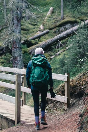
Before you head out on a Whistler hike, prepare yourself.
Since the pandemic, one of the biggest changes Whistler has witnessed is the explosion of interest in the Great Outdoors. People are getting out into the backcountry in record numbers.
But with this increased interest in our mountains and forests, there has also been a rise in backcountry emergencies. According to Whistler Search and Rescue’s (WSAR) ‘s annual report, from March 2020 to March 2021, they saw nearly a 40 percent increase in calls requiring mobilization.
So, how can you prepare for your hike in Whistler this Fall?
- Notify a friend or family member about your expected route, and return time.
- Research the trail conditions beforehand (via apps like All Trails or through local hiking groups).
- Wear warm clothes in layers.
- Pack extra warm clothing, including a hat, gloves, and a down layer.
- Bring a light, pocket knife, fire starter, and small first aid kit.
- Don’t forget enough water and food for the duration of the trip.
- Finally, stuff an orange garbage bag and thermal blanket into your backpack.
Whether you are headed off for one hour or two days, it doesn’t matter. If you step off-trail or injure yourself, you’ll be thankful these items are in your pack. Most of Whistler’s backcountry won’t have cell reception, so you may wish to pack a signal device for more substantial hikes.
And before you think, “I’m only doing an easy hike,” consider what WSAR manager Brad Sills told the Pique about the rise in calls. He said, “That’s basically the entry-level recreationalist, the one that’s disoriented or dehydrated, exhausted, people that have just overstepped their boundaries and are reaching out.”
Sills went on to say, “We see it in those three months of August, September and October. It’s typically entry-level pastimes like hiking.”
If you are hiking in Whistler in October (or anytime, really), you need to hike smart.
Weather and Mountain Conditions in Whistler in October
Between the hot, sweaty days of summer and the cold, snow-packed days of Winter, what can you expect when you hike Whistler in October?
Average High: 11° C | 52 ° F
Average Low: 3°C | 37 ° F
Average Number of Rainy Days: 13
Average Rainfall: 125 mm | 5 inches
Average Snowfall: 58 cm | 22 inches
Daylight Hours: 11
But, if you’ve ever read the snow report for Whistler, you know that elevation matters. With most of the hikes in Whistler heading up into the alpine, you’ll want to know temperatures for the start and end of your hike. So check the alpine conditions, as well as the general forecast.
5 Short and ‘Easy’ Hikes Around Whistler for Beginners
Never hiked before? No problem! There are hikes around Whistler that serve as good starting points. Typically this means short, less elevation, and well-serviced.
You may not make it to glacier-fed lakes, but the views you can walk to in an hour or two will take your breath away.
These are the best hikes near Whistler to hike in Fall that don’t require a ton of experience or advanced fitness ability.
1. Train Wreck Hike Whistler
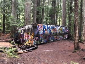
An easy hike for families, dog walkers and more near whistler
Where is it? The trailhead for Train Wreck starts in Function Junction, about 10 km south of Whistler Village. There is parking behind Olive’s Grocery Market, or you can make the hike a bit shorter (2.3 km) by starting at the Parking Lot for the Whistler Train Wreck (Trailhead here).
How long is it? 5km round trip. Allow 1-3 hours.
What’s it like? Easy walking with a few hills. Mostly along train tracks.
Other things to know: Bring a camera! Ask most Whistler locals, and they will admit to having had a mini photoshoot at Train Wreck. It’s one of the best hikes in Whistler for a photo op. Dogs are also allowed on this hike.
2. Parkhurst Ghost Town
Where is it? This magical hike is accessed via the Wedge Creek Forest Service Road, just north of Green Lake. The trail heads south towards the lake, and Parkhurst is on the North-Eastern side. Find the trailhead here.
How long is it? 7.7 km loop. Allow 2-3 hours.
What’s the elevation gain? 221 meters
What’s it like? Did you know Whistler has a long-abandoned ghost town? This trail does not have sweeping vistas, but it does have points of interest among the abandoned town.
Other things to know? The trail is a bit overgrown, so download a map beforehand.
3. Lost Lake Trail
Where is it? As the name suggests, this is a popular hiking trail around Whistler’s famous Lost Lake. Head over to Lost Lake (start here) and follow the Lost Lake Loop signs.
How long is it? 2.7 km loop. Allow for an hour (or less).
What’s it like? This is a great hike for families and those with some mobility issues.
Other things to know? It’s open year-round and is a great spot for a dog walk. Hiking it in October is a good option to avoid the crowds that descend on the lake and park during the summer months.
4. Callaghan Lake Hike
Callaghan country is a must-see hiking area near Whistler.
Where is it? Callaghan Lake is in the Callaghan Valley, 20 km south of Whistler. Watch for the Whistler Olympic Park sign and make a right, then follow the signs.
How long is it? This is a real beginner. You basically drive right to the lake and then can walk around and enjoy the views. You can also camp.
What’s it like? This hike is surrounded by snow-capped mountains and a gateway to many other hikes. Callaghan Valley is full of wildlife, so keep your eyes peeled and avoid leaving any food behind!
Other things to know: The last 10km is an unkempt logging road. It is in horrible condition, and caution needs to be used to avoid the endless potholes. 4×4 vehicle is required.
5. Loggers Lake Hike
Where is it? Loggers Lake is unique in that it is located in a century-old volcano. It is in Cheakamus Crossing, located in Whistler’s Interpretive Forest. Cheakamus is a short trip south of Whistler Village.
How long is it? 8km loop. Allow 3 hours.
What’s the elevation gain? 350 meters
What’s it like? Warm, isolated and peaceful.
Other things to know: Loggers Lake is the warmest in Whistler, so be ready to swim! It also boasts excellent fishing. Unfortunately, due to ongoing construction, park at Whistler Interpretive Forest’s main parking lot located on Cheakamus Lake Road.
5 Hikes Near Whistler for More Experienced Hikers
“Yeah, I’m in pretty good shape” can mean a lot of different things. You’ll need a decent level of physical ability, lots of water and a good attitude for the following trials.
If you have these, you can do these hikes. Whether it takes you two hours or ten, it will be worth it!
1. Joffre Lakes
Where is it? You’ll need a car to get to Joffre. From Whistler Village, you will drive 39 km north through Pemberton. You will see a sign for Lillooet where you will turn right. Follow the ascending highway and the signs and park in the official parking lot. Trailhead here.
How long is it? 11km roundtrip if you choose to see all three lakes (highly recommended!). Allow for 4 to 5 hours.
What’s the elevation gain? 400 meters
What’s it like? Joffre is stunning. Glacier-fed lakes surrounded by snow-capped mountains it is one of the most popular hikes. Many are brave enough to take a dip, but remember to bring a towel as the water is (literally) freezing!
Other things to know: Joffre has gained immense popularity over the past five years, meaning it is often crowded. Try to go mid-week/off-peak. October is perfect for this! You will still need to reserve a parking permit before you go.
2. Cheakamus Lake
Where is it? Head to Cheakamus Crossing across from Function Junction, 10 mins south of Whistler Village. Park at the trailhead (here), which is located at the end of Cheakamus Lake Road.
How long is it? 14km roundtrip. Allow 4 to 5 hours.
What’s the elevation gain? 403 meters
What’s it like? The trail takes you alongside the Cheakamus River through beautiful forests. It ends at the Cheakamus Lake campground, or you can go farther to the Singing Creek Campground. The final leg of this hike is along the lakeshore.
Other things to know: This area is the gateway to many more epic hikes, so bring some extra supplies in case you feel extra motivated! Camping options are also available. This Whistler hike is technically located in Garibaldi Provincial Park. You’ll need a day permit and/or camping permit before heading out.
3. Stawamus Chief

Hike the Chief for one of the easiest peaks around Whistler.
Where is it? The Chief (you probably won’t ever hear a local call it “Stawamus Chief”) is in Squamish, overlooking Howe Sound.
How long is it? There are three peaks on The Chief, all worth doing and all doable in one day. The first peak is a 6 km round trip. Allow one to two hours.
What’s the elevation gain? 600 meters
What’s it like? It’s steep. There are lots of stairs, and some areas are assisted by chains. If you have no hiking experience but are physically fit, this is a good challenge —but if you struggle with stairs, you’ll want to skip this hike. It is often referred to as “short but tough.”
Other things to know: Dogs are welcome, and so are rock climbers! Stawamus Chief Provincial Park must reserve a free day-use permit before arriving.
4. Rainbow Lake Trail
Where is it? The hike starts on Alta Lake road, right in Whistler. Look for signs for Rainbow Falls, trailhead here. You can even get there via the Valley Trail.
How long is it? 16km round trip. Allow 2.5 to 4 hours.
What’s the elevation gain? 850 meters
What’s it like? There are lots of bridges, waterfalls and gorgeous views, all good news in our books. You are constantly ascending. It is a long, well-used trail.
Other things to know: Rainbow lake is a water source for Whistler, so swimming, camping and fishing are prohibited.
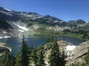
5. Garibaldi Lake Trail
Where is it? Garibaldi Provincial Park. Several hikes begin from Garibaldi Lake Trailhead (here), including Black Tusk, Panorama Ridge, and Rubble Creek. The Garibaldi Lake trailhead is at the end of Daisy Lake Rd.
How long is it? 16km roundtrip. Allow 4 to 6 hours.
What’s the elevation gain? 900 meters
What’s it like? One of the most stunning views you are likely ever to come across. The panoramic, turquoise lakes are surreal. It’s steep and is mostly switchbacks. If you have bad knees, this may be a tough one. The descent is steep and often requires jogging down, quite impactful on the knees.
Other things to know: This one dances between intermediate and advanced. There are no out-of-the-ordinary skills needed, but it is long and steep. There isn’t much to see until you get there, meaning it may feel like endless work with no reward. It also has a pristine campsite at the end. You’ll want to get a Garibaldi Provincial Park day permit or camping permit before arrival.
5 Hikes for the Avid Trekker (Camping Recommended)
If you do the Chief for your warm-up or Garibaldi on your slow day, it’s time to amp it up. With Whistler hikes, the effort really does correlate with the reward. The higher you go, the more breathtaking the hikes become (and not just because of thinner air).
In October, be sure to pack accordingly with warm layers, appropriate camping gear, and emergency supplies.
1. Panorama Ridge
Where is it? Same trailhead as Garibaldi lake, at the end of Daisy Lake Rd. It’s roughly 25 minutes south of Whistler, via Highway 99.
How long is it? 30km round trip. Allow ten or more hours for a day trip or one to three days for a backpacking trip.
What’s the elevation gain? 1540 meters
What’s it like? Indescribable really. You can look at photos and get the gist of it, but absolutely no photo comes close to doing it justice. You will be going up the whole time, and it will seem like it will never end. Garibaldi Lake makes a good lunch spot!
Other things to know: You can camp along the way, but all camping requires registration and a camping fee, check out the Garibaldi Provincial Park website for more information.
2. Black Tusk
Where is it? Also, in Garibaldi Provincial Park, this trail starts from the same Daisy Lake Rd Trailhead (just like Panorama Ridge, Garibaldi Lake and others). Starting to see a pattern of where all the epic hikes are, aren’t we?
How long is it? 27km round trip. Allow ten or more hours or make it an overnighter.
What’s the elevation gain? 1740 meters
What’s it like? Black Tusk is an epic monument of Whistler, as you can see it from pretty much everywhere. Whether skiing down from Peak Chair or driving the Sea to Sky, the massive rock fixture is a beauty. This hike near Whistler is a tad bit shorter than Panorama but a bit steeper.
Other things to know: You can camp along the way, but all camping requires registration and a camping fee, check out the Garibaldi Provincial Park website for more information.
3. Wedgemount Lake Hike
Where is it? Just a ten-minute drive north of Whistler, you will see the signs for Garibaldi Provincial Park. Enjoy beautiful views of Green Lake along the way, and turn on to the Wedge Creek FSR.
How long is it? 14 km roundtrip. Allow seven or more hours.
What’s the elevation gain? 1400 meters
What’s it like? Hard. Really hard. But nothing great ever comes easy, right? So even though it is half of Panorama or Black Tusk, the elevation gain is similar, meaning it is steep.
Other things to know: The steepness doesn’t require any technical skill, but the final ascent will likely have you on all fours — it’s a scramble. Pack as lightly as possible (but lots of water!) and make sure your shoes have a good grip.
4. Cirque Lake Hike

If there is a hikers best kept secret – it’s cirque lake. Canoe required!
Where is it? It sits above Callaghan Lake, the same lake mentioned at the beginning of this blog. You can drive to it on the Callaghan Lake FSR, which is about twe20nty minutes south of Whistler.
How long is it? 4 km round trip. Allow 1 hour — But, neither of these statistics include the water portion.
What’s the elevation gain? 300 meters
What’s it like? If you’re looking for serenity, here it is. You need more than just your feet for this one. The hiking involved is actually pretty minimal—only about 4km with a 300-meter elevation gain. The trailhead, however, is a 2 km paddle across Callaghan lake. If you are looking for one of the best hikes in Whistler, but without the crowds… this is it!
Other things to know: It’s called cirque lake for a reason! Go see for yourself. Okay, this one is for the really avid outdoorsy type because it actually requires a canoe/kayak.
5. Russet Lake Hike
Where is it? This is a unique hike because it’s accessed by Whistler mountain. Head to Whistler Village and the Whistler Village Gondola to find the Singing Pass trail. The gondola isn’t always operational during the shoulder season, so you’ll need to start by physically hiking up the mountain.
How long is it? 30 km round trip. Allow 10 hours to return or 5 to the campsite.
What’s the elevation gain? 1400 meters
What’s it like? This is a great introduction to trekking because the trailhead is located right in Whistler Village. The entire trail has a steady incline, with most of it through the trees. The final end opens up into beautiful meadows.
Other things to know: You will need a day pass or camping pass for Garibaldi Provincial Park. Secure these before setting off. You can reserve a hut in advance, or there are plenty of tent spots.
Where to Hike in Whistler in Fall?
If you want to hike Whistler but avoid the crowds and sweaty weather, October is the best time of year. Head into the mountains when you visit Whistler this shoulder season and challenge yourself with some of the best hiking in BC.
Charge your camera, grab your most motivating friend, and make this October one to remember. Just because its Fall doesn’t mean British Columbia hiking opportunities come to an end. Some may even argue they are at their “peak.”