Best Places to Hike in Whistler | Spring, Summer, Fall, Winter

Exploring Whistler by foot is a brilliant way to get deep into the wilderness of the Coast Mountains. But when it comes to whistler hikes, the first rule is seasonality. Hiking trails in Whistler vary between deep forested valleys and snow-covered mountain peaks — which means timing matters.
The good news? You can enjoy hiking in all 12 months of the year here. However, late summer and early fall offer the most options when the snow has melted to reveal green grass and well-trodden hiking paths.
But if you visit in winter, don’t let the snow get in the way of your excursion. Just strap on some snowshoes! Read on to see which Whistler hike is best for you.
Grab a map, pack a day bag, and set off on your adventure. The following guide breaks down popular whistler hiking trails by:
- Season
- Difficulty
- Distance
Better yet? Why not let the local experts show you around? Whistler Adventures offers fantastic hiking tours with an experienced guide.
Best Whistler Hikes in Winter
Just because everyone is hitting the slopes in winter doesn’t mean there aren’t any Whistler hiking trails open. If you have a pair of crampons, or better yet, a pair of snowshoes, you can still get out.
Better yet? Even the busiest hiking trails will be a place of serenity and calm during the cold season. You’ll get breathtaking mountainscapes, with nobody to crowd the view.
While most trails will stick to valleys in winter if you do decide for more of a backcountry challenge, stay safe. We recommend booking a guided whistler hiking experience or taking your avalanche safety training.
Train Wreck
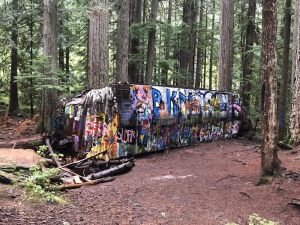
An easy hike for families, dog walkers and more near whistler
- Difficulty: Easy
- Distance: 5.8 km
One of the most iconic Whistler hikes has got to be the Train Wreck. Seven mangled train cars lie scattered in the woods next to the Cheakamus River.
This unique site is visited by graffiti artists, hikers, locals, tourists, families, photographers, bikers, and everyone in between.
Whistler History Bite
So how did these boxcars come to lie in the middle of a dense forest? In 1956, a train derailed in the area. A local logging company was called in to remove the debris. The train cars were rolled into the forest, where they remain today.
The suspension bridge, completed in 2016, now makes this spectacle easy and safe to reach. Moreover, it’s straightforward to get to, as the trailhead is located just 15-minutes down the road from Whistler Village, at Cheakamus Crossing.
Along with a colourful train wreckage, you’ll witness the fierce, emerald green Cheakamus River, which is an astonishing sight in itself. The Train Wreck is accessible all year-round, although you might be required to use snowshoes if there’s been heavy snowfall.
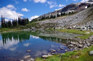
Crater Rim and Farside Loop Trail

A sneak peak of Loggers Lake in Summer.
- Difficulty: Moderate
- Distance: 8.7 km
If you have already walked to Whistler’s iconic Trainwreck hike, why not stick around the Whistler Interpretive Forest to check out the Crater Rim and Farside Loop Trail? This hike takes you to Loggers Lake, which is technically inside an extinct volcanic crater.
Most of the trail meanders through dense forest, with views along the Cheakamus River, with one point crossing over a suspension bridge.
This is an excellent trail in summer, but may we suggest it as a winter adventure. Bring crampons for the ice and snowshoes if there has been a recent snowfall. In the winter, the crowds thin out, and you’ll likely have this trail to yourself!
Joffre Lakes
- Difficulty: Difficult
- Distance: 7.7 km
If you’ve seen pictures of Whistler’s alpine lakes in your Instagram feed, you’ve likely seen the beauty of Joffre Lake Provincial Park. This park offers several levels of hiking trails, from simple day trips to overnight backcountry adventures.
In deep Winter, Joffre Lakes Provincial Park is a true winter wonderland. Drive 75 minutes north of Whistler to reach the trailhead. Hiking up past these three exquisite, mind-blowing blue lakes in the wintertime is a beautiful and unforgettable experience.
Snowshoes are a must. The trail is well-marked and usually tracked out, but with 400 meters of elevation gain and 11 kilometres to trek in total, this hike is not for the faint-hearted!
Choose a sunny day and marvel at the dazzling frozen lakes. Plenty of caution should be taken, and be sure not to visit after a period of heavy snowfall when the risk of avalanches could be significant.
Need to Know:
Before heading to Joffre Lakes Provincial Park, you’ll need to secure a free day-use permit. Go online in advance to reserve yours. In winter, you’ll also want to check on backcountry and avalanche conditions for the area. Take your avalanche safety course and bring the right gear with you.
Where to Hike in Whistler in the Spring
Even if it’s lake weather in Whistler Village, many of Whistler’s best trails are still buried in snow during the Spring season. But, not all hiking trails in Whistler are off-limits.
Whistler hikes in spring tend to wander through the lower forests to avoid the glacier melt. By sticking with lower elevations and still having a pair of crampons at the ready, Whistler’s springtime hikes are a great way to get out of the crowds and see a snapshot of the landscape.
Snow Walls on Whistler Mountain
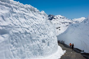
A unique hike to Whistler, hike up the mountain along the massive melting snow roads
- Difficulty: Easy
- Distance: 3.8 km (or 7.6 km roundtrip)
While the snow in the valley has disappeared by May, a blanket of the white stuff still glistens on the mountain peaks. Whistler Blackcomb carves an impressive path through metres of snow every spring, leaving a labyrinth of snow walls for you to walk through.
To access these giant spectacles, buy a sightseeing pass (purchase online for the best rates) and upload the Whistler gondola. From the Roundhouse Lodge, you’ll see the snow walls. Then, follow them up Pika’s Traverse Road and watch in wonder as they grow in size as you progress along the trail.
Give yourself 60 to 90 minutes to complete the round trip, then why not enjoy a spot of lunch at the Roundhouse Lodge and take a ride on the PEAK 2 PEAK Gondola for incredible 360-degree views of the valley before descending back to Whistler Village.
These canyons of snow do not last forever! As the warm sun beams down on them, these snow walls decrease in size every day, so our advice is to go up and see them as soon as you can once they open. You’ll need a Peak 2 Peak 360 Experience pass to access.
Tunnel Bluffs
If you are visiting Whistler in Spring, and desperate for elevation check out Tunnel Bluffs in Lions Bay
- Difficulty: Moderate
- Distance: 10.9 km
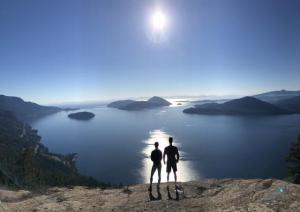
Although technically closer to Vancouver than Whistler, we had to throw this hike in the mix for the magnificent views that you’ll witness at the top of it.
Plus, it’s at a lower elevation than most of the other best hikes in Whistler, BC, so that means easier access. As a result, this trail is one of the first in the Sea to Sky corridor that you can enjoy in spring.
The trailhead for this eight-kilometre hike (leave around 4.5 hours to complete it) is just a couple of metres from Highway 99. It is super accessible and a great one to do if you’re heading back to Vancouver.
From Whistler, drive south for around an hour, and you’ll reach a very small parking lot. On a nice day, this is often full, so be prepared to find parking elsewhere off the highway. Be extremely careful when crossing this busy stretch of road!
The hike itself is a steep climb with 650 metres of elevation. The path is well-trodden and easy to follow, but the ground is sometimes wet and muddy, so hiking boots or good, grippy runners are a must.
After about an hour and a half of constant incline, you’ll follow a flat section of an old logging road before reaching the summit of this hike. Now, take a while to catch your breath and marvel at the absolutely outstanding views of Howe Sound.
Brandywine Mountain
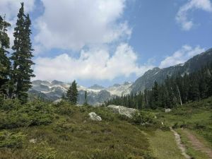
Challenge yourself with the full Brandywine experience by heading to the peak.
- Difficulty: Difficult
- Distance: 15.8km
If you are looking for a challenge in late spring, look no further than one of Whistler’s best-kept secrets: Brandywine Mountain.
This whistler hike is about 30 minutes south of the Village, up the Callaghan Valley Road. Once on the Valley Road, turn left on the Brandywine FSR. Follow this road until you see signs for the lower parking lot. If you have a good 4×4 vehicle with a lift, you can cut the hike down by accessing the upper parking lot.
Over the 16 km trail, you’ll gain nearly 1,500 meters in elevation, making this ideal for experienced trekkers. Expect an intense forested trail interlaced with alpine creeks.
As you get to the finish line, you’ll wander through Brandywine Meadows and have views of the peak. Then from the peak, you’ll have your breath taken by sweeping views of the valley.
Pack appropriately for the season, which means crampons, layers, and maybe snowshoes depending on recent snowfall. Check backcountry conditions before you go.
Where to Hike in Whistler in the Summer
When summer comes around, and the snow melts from the slopes, biking and hiking become the activities of choice on Whistler and Blackcomb mountains.
You’ll have greater and greater access to the mountains as the snow melts. By the end of July and into August, most trails are accessible (although some equipment may still be necessary).
There are many scenic trails on both mountains, including the strenuous but utterly beautiful High Note Trail on Whistler and Decker Loop Trail on Blackcomb. Harmony Lake Loop on Whistler Mountain
Harmony Lake Loop Trail
In our books Harmony Lake Loop is a bucket list for Whistler hiking.
- Difficulty: Easy
- Distance: 2.7 km
The Harmony Lake Loop Trail is easy, epic, and kid-friendly! To reach the start of this hike, you must purchase a sightseeing lift ticket and take the 22-minute ride up to Whistler Gondola.
Harmony Lake Loop is 1.9 kilometres in length and will take you around 90 minutes. This mellow Whistler hike will take you through stunning alpine forests to Harmony Lake. It’s a great hiking option if you’ve got young kids in tow, as it’s accessed from the Roundhouse Lodge, with minimal elevation gain. (Speaking of which, do you need more ideas for Whistler with kids?)
While you’re up Whistler and Blackcomb mountains, you can also ride the record-breaking PEAK 2 PEAK Gondola or take a daunting walk over the Cloudraker Skybridge.
Whistler Peak: Half Note to High Note
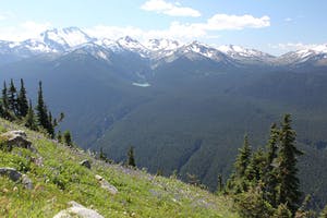
Alpine flowers and memorable views on the High Note Trail.
- Difficulty: Moderate
- Distance: 9.2 km
Another trail accessed with a PEAK 2 PEAK 360 Experience pass, this trail takes you from Half Note to High Note and back again. However, thanks to the gondola, this is a low-effort maximum reward trail — plus, you can end the hike with a tasty reward at the Roundhouse.
The trail starts and ends at Roundhouse. Take either the Whistler Village Gondola or the PEAK 2 PEAK Gondola. Much of this loop traverses. However, there are some steeper sections to note.
In late summer, expect the wildflowers to be out in force. Plus, the views of the surrounding mountains will seemingly go on forever. It’ll also be quite hot on top in the summer, so be sure to pack plenty of water and sun protection.
Rainbow Lake
Want to cool off? Head to the alpine
- Difficulty: Difficult
- Distance: 15.6 km
Another of our favourite Whistler hikes is Rainbow Lake. Best hiked from June to October, the trek up to this beautiful lake features 850-meters of elevation gain, so it’s bound to get your heart pumping.
The trailhead is marked with a large sign, so it is easy to spot. Rainbow lake trailhead is just a 10-minute drive from Whistler Village off Alta Lake Rd. Expect a consistent uphill ascent through a deep cool forest with spectacular views of Whistler and Blackcomb mountains. You’ll pass stunning waterfalls and arrive at the top to find a pristine glacial body of water.
Camping is not allowed because this ice-cold lake supplies Whistler with water, so all 16km of this hike (that’s the round-trip distance) have to be done in a day. So give yourself between five and eight hours, and be prepared for a steep climb!
Unfortunately, dogs are also not permitted on this trail, so leave your furry, four-legged friends at home!
Where to Hike in Whistler in the Fall
Fall in Whistler is characterized by rain, and usually lots of it! Yet the wet weather, September and October, are usually perfect for hiking.
By fall, the sweltering summer conditions have subsided. Better yet, the snow has finally melted from high-elevation hiking trails that were inaccessible for most of the summer.
Parkhurst Ghost Town
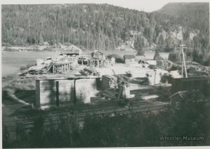
Head off the beaten path with this easy Whistler hike. Image: Whistler Museum
- Difficulty: Easy
- Distance: 7.7km
Long before Whistler was the bustling, world-class resort that it is today, a small logging town named Parkhurst existed in the forests near Green Lake. In 1966, after 40 years of being occupied by around 70 loggers, Parkhurst was abandoned.
Meandering through the deserted town today, you can spot remnants of its past in every direction. From half-collapsed wooden houses to rust-covered cars and ancient household appliances, explore the historical relics of Whistler’s community that used to be.
This seven-kilometer round trip hike has no elevation gain, so it is rated easy on our difficulty scale! There are at least five ways to reach the ghost town, including by boat. Although many trail markers are leading the way, getting lost is inevitable.
We love this Whistler hike because it is close to the Village (the trailhead is 13 kilometers away) yet feels remote. Go check out this spooky ghost town!
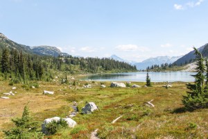
Cheakamus Lake Trail
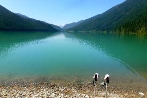
A relatively easy hike, with a beautiful lake at the end.
- Difficulty: Moderate
- Distance: 14.3 km
Cheakamus Lake is a busy trail near Whistler, but for a good reason. This out-and-back trail leaves from the end of the Cheakamus Forest Service Road and heads upwards, over 14 kilometers and 400 meters of elevation.
It wanders through ancient forests and beside the Cheakamus river. At the end, you’ll hit Cheakamus Lake, an aquamarine alpine lake. Surrounded by forests and mountain peaks, this makes for a great pit stop.
While you can complete this hike in a long day, you can also make this an overnighter. In early fall, you’ll want to bring your bathing suit for a refreshing dip in the lake!
Be sure to grab your Garibaldi Provincial Park day-use permit (or camping permit) before you leave.
Panorama Ridge
- Difficulty: Difficult
- Distance: 28.3 km
Panorama Ridge is a great hiking choice in early fall (the snow only melts from it in late summer). In our books, it’s one of the best hikes in Canada.
To reach the start of the trail, drive 25 kilometers south of Whistler Village to Rubble Creek. This 30-kilometer round trip hike features 1520 metres of elevation gain and will take you eight to 10 hours. Complete it in a single day if you’re up for a challenge, or why not camp in the spectacular Garibaldi Park.
We can confirm this is a jaw-dropping beautiful hike. It covers alpine meadows, dense forests and culminates with incredible panoramic views over Garibaldi Lake at the summit. It’s worth every aching step!
Don’t forget to secure your Garibaldi Provincial Park day-use permit before arriving — it is free!
Check out our guide to the 5 peaks to summit around Whistler for more backcountry hiking ideas.
Take a Hike in Whistler, BC!
Whistler boasts some of the best hikes in Canada, offering outstanding natural beauty and rewarding adventure. Can you think of many better ways to appreciate BC’s landscape for free?
From mellow walks to enjoy with the whole family to multi-day hikes through rugged terrain, there are few places in the world where you can experience such spectacular and varied trails.
So decide how active you’re feeling, choose a Whistler hike, and set off to explore the beautiful Coast Mountains on foot. You won’t regret it!